


Experience Fall Colors in Payson and Mogollon Rim Country
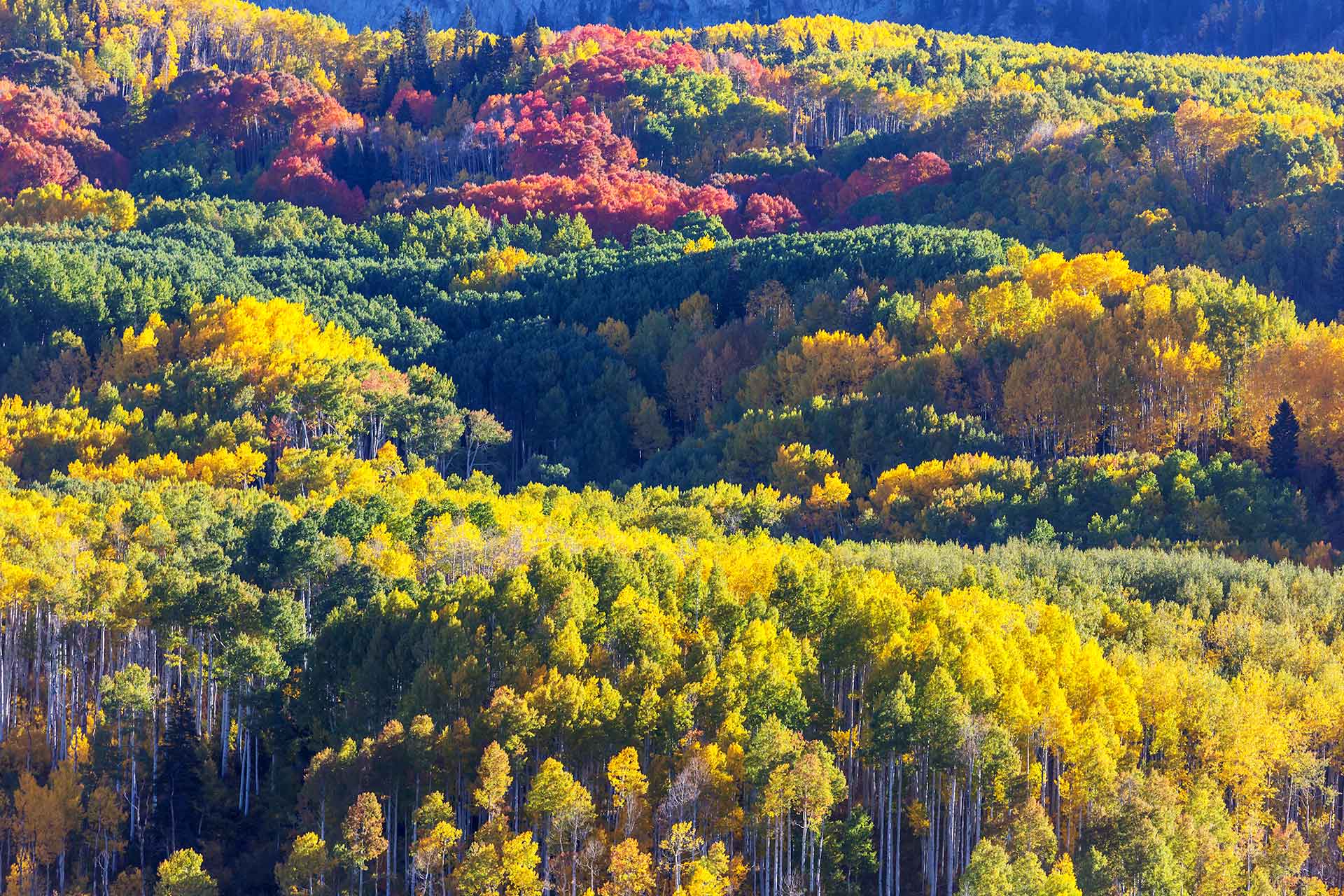
During the fall months, Payson and the surrounding Mogollon Rim Country transform into a vibrant landscape of golden aspens, fiery maples, and glowing oaks. Cooler temperatures and crisp mountain air make this one of the most enjoyable times to explore Rim Country. Thanks to Northern Arizona’s mild climate and nearly year-round sunshine, viewing fall foliage is both comfortable and scenic—perfect for a day trip or weekend getaway.
Just a short drive from the Valley, Payson is an easy escape into autumn beauty. Pack a jacket and your hiking boots and head up the hill to enjoy colorful trails, peaceful pine forests, and unforgettable sunsets over the Rim. Whether you’re hiking, biking, or taking a scenic drive, the views this time of year are truly spectacular.
Peak Fall Colors
Mid-to-late October is typically the best window for peak fall color in the Payson area. Some of the most popular spots for leaf peeping include the Mogollon Rim, Tonto Natural Bridge State Park, and the East Verde River area. Be sure to bring your camera—Payson’s fall foliage is a seasonal sight you won’t want to miss.
Areas to Explore
During the fall months, Payson and the surrounding Mogollon Rim Country transform into a vibrant landscape of golden aspens, fiery maples, and glowing oaks. Cooler temperatures and crisp mountain air make this one of the most enjoyable times to explore Rim Country. Thanks to Northern Arizona’s mild climate and nearly year-round sunshine, viewing fall foliage is both comfortable and scenic—perfect for a day trip or weekend getaway.
Just a short drive from the Valley, Payson is an easy escape into autumn beauty. Pack a jacket and your hiking boots and head up the hill to enjoy colorful trails, peaceful pine forests, and unforgettable sunsets over the Rim. Whether you’re hiking, biking, or taking a scenic drive, the views this time of year are truly spectacular.
Mid to late October is typically the best window for peak fall color in the Payson area. Some of the most popular spots for leaf peeping include the Mogollon Rim, Tonto Natural Bridge State Park, and the East Verde River area. Be sure to bring your camera—Payson’s fall foliage is a seasonal sight you won’t want to miss.
Just 10 miles north of Payson, Arizona, Tonto Natural Bridge is home to the largest natural travertine bridge in the world. Surrounded by towering pine forests and set in a scenic box canyon, this one-of-a-kind geological marvel offers waterfalls, hiking trails, and stunning viewpoints—making it a favorite destination for families, outdoor enthusiasts, and photographers.
During the fall months, the area comes alive with vibrant autumn colors, providing an added layer of beauty to your visit. Golden foliage contrasts against the lush evergreens and rugged rock formations, creating a picture-perfect setting for a seasonal hike or picnic.
To visit, head north on State Route 87 from Payson, turn left on Forest Road 583, and follow the signs for 3 miles to the park’s Welcome Center. As a designated Arizona state park, entrance fees and seasonal hours apply—be sure to check the official website before you go.
Several short trails offer different views of the bridge, with options for all activity levels. Some paths lead to waterfalls and caves, while others provide panoramic overlooks of the Mogollon Rim and the travertine arch from above.
A trip to Tonto Natural Bridge is a must when exploring Payson and Arizona’s Rim Country.
Panoramic Ridges and Fall Colors
Located just south of the town of Strawberry, the Pine/Strawberry Trail offers scenic views and a peaceful Rim Country experience. To reach the trailhead from Payson, drive 17 miles north on State Route 87. The dirt trailhead is on the south side of the highway, just before entering Strawberry.
This 4-mile trail runs along the side of Strawberry Mountain and features sweeping, unobstructed views of the Mogollon Rim, Pine, and the Mazatzal Mountains. In the fall, the area near the trailhead lights up with beautiful autumn colors, making it an ideal spot for a seasonal hike or photo stop.
The Pine/Strawberry Trail connects with the Goshawk, Mohawk, and Towhee trails, offering visitors multiple route options and opportunities to explore more of the area’s natural beauty. With its stunning views and varied terrain, this trail is a favorite for hikers, birdwatchers, and nature lovers alike.
Scenic Access with Stunning Fall Colors
The Washington Park Trailhead offers access to some of the most beautiful terrain in Rim Country—especially in the fall. To get there from Payson, take Houston Mesa Road for 10 miles, turn left onto the Control Road for ¾ of a mile, then head north on Forest Road 32 for 4 miles to the signed trailhead.
This area is particularly breathtaking in autumn, when the surrounding forest lights up with vibrant reds, oranges, and golds. Cottonwoods and maples along the East Verde River and throughout the nearby canyons provide an unforgettable fall color display.
The East Verde River crosses the historic Highline Trail here, and one of the most popular hikes is the Railroad Tunnel Trail, which features forested paths and a 700 ft tunnel bored right into the side of the Mogollon Rim. Heading west from Washington Park, the Highline Trail opens up to sweeping vistas and eventually drops into the scenic Webber Creek drainage at the Geronimo Trailhead.
Fall Colors and Fresh Spring Views
Horton Creek Trailhead is a favorite Rim Country hiking spot, especially in the fall when the forest comes alive with vibrant color. To get there from Payson, drive 16 miles east on Highway 260 and turn left onto Fish Hatchery Road, just across from Kohl’s Ranch. The trailhead parking area is about a mile in on the right, just after the Tonto Creek bridge. Vault toilets are available at the parking area.
The Horton Creek Trail is a 3-mile route that gradually climbs 1,000 feet through a shady canyon filled with towering ponderosa pines, firs, and colorful hardwoods. In autumn, the changing leaves of maple, oak, and other deciduous trees line the creek, making this one of the most scenic fall hikes near Payson.
The trail ends at the base of the Mogollon Rim, where it meets the historic Highline Trail. Hike another 100 yards upstream to find the source of Horton Creek—clear spring water pouring straight from the rocks at the base of the Rim. With its cool temps, colorful foliage, and flowing water, Horton Creek Trail is a must-visit for fall hikers.
Fall Colors, Creek Crossings, and High Country Beauty
Located just 16 miles east of Payson, the Hatchery Trailhead offers access to one of the most scenic stretches of the historic Highline Trail. To reach it, turn left off Highway 260 onto Fish Hatchery Road—directly across from Kohl’s Ranch—and continue 4 miles to the trailhead.
This trailhead is named for the nearby Tonto Creek Fish Hatchery, a popular family stop where cold, clear waters flow year-round. In the fall, Tonto Creek and the surrounding forest put on a spectacular show of autumn color. Brilliant reds, oranges, and golds light up the canyon, making this area one of the most beautiful spots in Rim Country for a seasonal hike or photo opportunity.
Known as “The Inner Sanctum,” this 20-mile section of the Highline Trail is celebrated for its remote beauty, world-class singletrack, and numerous creek crossings. It’s a favorite among hikers, mountain bikers, and nature lovers seeking a peaceful escape surrounded by vivid fall foliage. For those looking to enter mid-way, Forest Road 144 off the Fire Control Road offers additional access.
Whether you’re leaf-peeping, exploring the trail, or visiting the hatchery, the Hatchery Trailhead is a must-see in autumn.
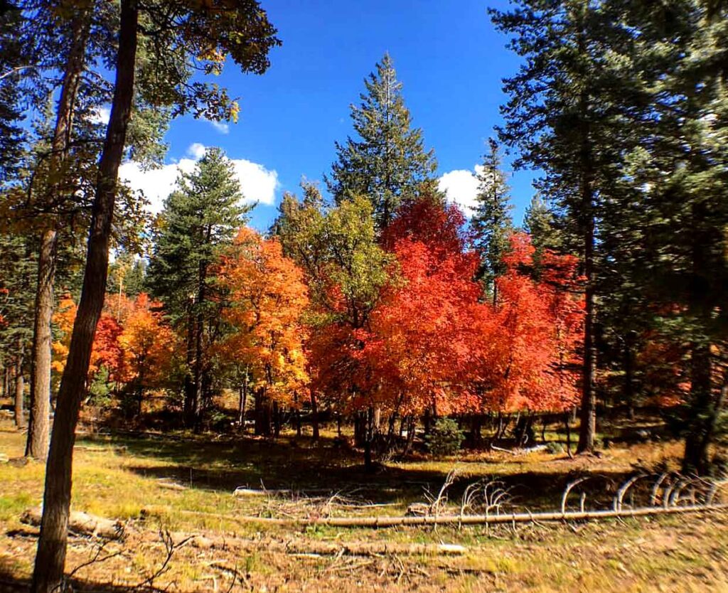
Fall Colors and Canyon Adventure
See Canyon Trailhead is a favorite fall destination for hiking, biking, and fishing in the heart of Rim Country. To get there from Payson, take Highway 260 east to Christopher Creek. Turn onto Forest Road 284, just across from the Landmark at the Creek Restaurant, and follow it for 3 miles to the trailhead. The area offers dirt parking and a vault toilet for convenience.
In autumn, the canyon transforms with brilliant fall colors—glowing reds, golds, and oranges from maples, oaks, and other hardwoods create a stunning contrast to the evergreens. Christopher Creek, which flows across the trail near the start, adds to the peaceful beauty of the area.
The See Canyon Hiking Trail is a challenging but rewarding climb, ascending more than three miles to the top of the Mogollon Rim. For those heading west on the Highline Trail from the trailhead, expect sweeping views, dramatic red rock sections, and towering ponderosa pines.
Whether you’re chasing fall colors, fishing along the creek, or taking on a scenic climb, See Canyon Trailhead is a must-visit location in the Payson area—especially during peak autumn months.
Eastern Gateway to the Highline and Stunning Fall Scenery
Located 25 miles east of Payson along Highway 260, the 260 Trailhead marks the eastern starting point of the historic Highline Trail. This trailhead features a dirt parking area and a vault toilet, making it a convenient launch point for hikers, mountain bikers, and backpackers.
Just west of the trailhead, the Military Sinkhole Trail connects to the Highline. From there, the first three miles offer a mix of short climbs and fun downhill stretches through pine-covered terrain. After reaching the junction with the Drew Trail, the route begins a dramatic descent into the Christopher Creek drainage—one of the most scenic sections of the trail.
In the fall, this area becomes especially vibrant. As the trail drops into the drainage, hikers are treated to brilliant displays of autumn color from maples, oaks, and other deciduous trees that line the canyon. The mix of red, orange, and gold foliage contrasted with evergreens and rocky cliffs makes this one of the most picturesque fall hiking spots along the Highline.
For those seeking elevation, color, and adventure, the 260 Trailhead offers an unforgettable starting point.
